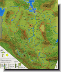
the Lunar Empire (951kb)
drawn by Wesley Quadros & Martin Laurie
from Glorantha Maps - Regions
in Hero Wars
|
ルナー帝国の地図の、最終決定版。その詳しさ、美しさは比類がない。 |

Erigia (237kb)
drawn by Wesley Quadros
from Maps of the Middle World
in Wesley's Glorantha Site III
|
"Lunar Map Final" と同手法で描かれたエリギアの地図。 |

Tarsh (231kb)
drawn by Wesley Quadros
from Maps of the Middle World
in Wesley's Glorantha Site III
|
"Lunar Map Final" と同手法で描かれたターシュの地図。 |

Eastern Hydra Mountains (143kb)
drawn by Wesley Quadros
from Maps of the Middle World
in Wesley's Glorantha Site III
|
"Lunar Map Final" と同手法で描かれたオルムスゴーン渓谷の地図。 |

the Lunar Empire (232kb)
drawn by Wesley Quadros
from Maps of the Middle World
in Wesley's Glorantha Site III

the Lunar Empire (27kb)
drawn by Matti Järvinen
from Maps of Glorantha
in Matti Järvinen’s homepage

Political Division in the Empire - 1634 (626kb)
drawn by Wesley Quadros after Martin Laurie
from Maps of the Middle World
in Wesley's Glorantha Site III
1634年における旧ルナー帝国の勢力分布図です。
この大胆な解釈をあえて受け入れるなら、帝国はアーグラスの擡頭以前に崩壊を始めていた感がありますね。

the Oronin Valley (38kb)
drawn by Phil Anderson
from The Oronin Valley
in Etyries.com
|
Phil Anderson の手になるこの地図では、"Lunar Map Final" では小都市としてしか分からない幾つかの地点が、門前町であることが分かる。地図自体は美しいだけでなく、透過 GIF で作られており、パピルスでも羊皮紙でも、あなたの望む紙の上にこの地図を置くことが出来る。 Through this map was drawn by Phil Anderson, you can understand some small cities have each temples. This map is not only beautiful, but also useful. This map is drawn as the Permeability GIF, and you can put this map on some papers that you like (a papyrus, a parchment and so on). |

the Western Reaches (30kb)
drawn by Kevin McDonald
from The Western Reaches
in Lions of Rhugandy Hero Wars Campaign

the Oronin Valley (19kb)
drawn by Matti Järvinen
from Maps of Glorantha
in Matti Järvinen’s homepage
Jernalf 丘陵の名が初めて記されいる。

Vanch (15kb)
drawn by Matti Järvinen
from Maps of Glorantha
in Matti Järvinen’s homepage
まず、Silverstone 川、北ヴァンチ平原の名が初めて記されおり、"Lunar Final Map" には見られない、Outer 丘陵、Divide 丘陵、Thorn 丘陵、 Guardian 丘陵といった地形、Dorarleya 、Rsyosta 、Alatelon 、Olamstina 、Zulox 、Hilltown 、Hojasinestel 、Kareiston's Temple 、Tor Balur といった諸都市が書き込まれている。
また、Alornik 市は Bokisin 川の左岸にあり、バイソン平原は南ヴァンチ平原、Daughter Rose 市は Old Rose 市、Sidherius 市は Sidara 市、ミリンズ・クロス市は Urar Baar 市となっており、Hortugarth 市には、Tor Vara の名が付記されている。
Matti Järvinen 氏の手になるこの地図は、"Enclosure2" に拠ったものらしい。

Dorastor (19kb)
drawn by Matti Järvinen
from Maps of Glorantha
in Matti Järvinen’s homepage
|
ドラストールに関して、最も詳しい地図。 |

Balazar (40kb)
drawn by Malion
from Balazar
in TOME: The Book of Secrets of Glorantha
日本語で記されており、"Lunar Final Map" では切れている古き荒野や街道も描かれている。

Balazar (18kb)
drawn by Matti Järvinen
from Maps of Glorantha
in Matti Järvinen’s homepage
上述の まりおん 氏の地図と同じ範囲を扱った地図。こちらの方が鮮やかで見やすく、また Soldier Ferry への街道が加えられている。
"Lunar Final Map" との比較では、こちらで初めて Spit 丘陵、West 平原の名が知られ、Selkow's Hill と Look Hill が書き加えられている。

Votankiland (1,378kb)
from Votankiland
|
バラザール地方のヘックス・マップ。 |

Yolp (100kb)
drawn by James Frusetta
from Map of Yolp
in Wonderhome

Tarsh (98kb)
drawn by Piroki
from Maps of Tarsh
in Gathering Storm
|
日本語で読めるターシュの地図。 |

Tarshite tribes (118kb)
drawn by Piroki
from Maps of Tarsh
in Gathering Storm
|
日本語で読めるターシュの20部族の地図。 |